
Punjab State Board PSEB 10th Class Social Science Book Solutions Geography Chapter 1 India: An Introduction Textbook Exercise Questions and Answers.
PSEB Solutions for Class 10 Social Science Geography Chapter 1 India: An Introduction
SST Guide for Class 10 PSEB India: An Introduction Textbook Questions and Answers
I. Answer the following questions objectively :
Question 1.
What is the basis of naming Bharat as ‘India’?
Answer:
India got its modern name from Sindhu river.
Question 2.
What is the situation of India on the globe?
Or
What is geographical position of India on the globe? (Pb. 2019)
Answer:
It is situated in the Northern hemisphere.
Question 3.
What are the geographical divisions of Northern and Southern India?
Answer:
Plain and Plateau Division.
Question 4.
What is the location of India in respect of Indian Ocean?
Answer:
India has central position in Indian Ocean.
Question 5.
Which countries came in direct contact with India because of the nearness of its coastal boundaries with Indian ocean?
Answer:
Maldeep , Sri Lanka.
Question 6.
What are th/e evidences for the powerful naval force of India?
Answer:
India’s naval army tried to curb the terrorism in Sri Lanka in last decade.
![]()
Question 7.
What is the extent of India?
Answer:
India extends between 804’ and 3706′ north latitude and 6707′ and 97025′ east longitude.
Question 8.
What is the area of India?
Answer:
The area of India is almost 32,87,263 square kilometres.
Question 9.
Compare the area, currency, population and literacy of India with that of Pakistan?
Answer:
Do it Yourself with the help of your teacher.
Question 10.
What is the North-South and East-West extent of India?
Answer:
The North-South extent of India is 3214 km and East-West extent is 2933 km.
Question 11.
What is the length of land and coastal boundaries of India?
Answer:
The length of land frontiers is 15,200 km. and the length of coastal boundaries is 7,517 km.
Question 12.
What do you mean by sub-continent?
Answer:
A subcontinent is part of a larger continent. It is made up of a number of countries that form a large mass of land. The subcontinent is often used to refer to the area that contains India, Pakistan, and Bangladesh.
Question 13.
What is Cultural fusion?
Answer:
Cultural fusion is a phenomenon which emerges when two or more cultures inter¬mingle and produce a new culture.
Question 14.
What is the rank of India in the world in terms of area?
Answer:
India ranks seventh in the world in terms of area.
Question 15.
Which countries share the land frontiers with India?
Answer:
Pakistan Nepal Bhutan, Myanmar (Burma) and Bangladesh and China.
Question 16.
What were the political division of India before Independence?
Answer:
- Princely State
- British Provinces.
Question 17.
What work was done by the State Reorganization Commission?
Answer:
It reorganised boundaries of the states on linguistic basis.
![]()
Question 18.
When was the present Punjab state created?
Answer:
Present Punjab came into existence on November 1st, 1966.
Question 19.
What is the present administrative division of geographical set up of India?
Answer:
India has 28 states and 8 union territories.
Question 20.
Name the largest and smallest States of India in terms of area and population.
Answer:
Rajasthan is the largest and Goa is the smallest state of India in terms of area. Uttar Pradesh is the largest and Sikkim is the smallest state of India in terms of population.
Question 21.
What is the number of members in the two houses of Parliament?
Answer:
- Lok Sabha-545
- Raya Sabha-250.
Question 22.
Name some of the important religious places of India.
Answer:
Amritsar, Bodh Gaya, Badrinath, Varanasi, Allahabad etc
Question 23.
To which regions of India major groups of people came through migration.
Answer:
From villages to urban areas.
![]()
Question 24.
In which areas/fields the country has failed on large scale?
Answer:
To provide Employment to a large population
Question 25.
Write the names of major folk dances of India.
Answer:
Bhangra. Gidha, Bhart Natyam, Kyttchipuddi etc,
II. Answer the following questions in short :
Question 1.
Is India a sub-continent?
Or
What is a sub-continent?
Answer:
India is called a sub-continent on the basis of its size and location :
- Physical features separate it from adjoining areas.
- In the Northern part, Trans Himalayan ranges Aghil, Muztagh, Kunleun, Karakoram and Hindukush separate it from N.W. of Asia.
- Palk Straits and Gulf of Manar separate it from Sri Lanka in the South. Arakans separate it from Burma (Myanmar) in the East.
Question 2.
What type of cultural diversities are found in India?
Answer:
People belonging to different Religions and castes live in different parts of India. Great diversity is found in their languages, food, clothing and mode of living. Their folk songs, festivals, fairs and customs are different. There are 187 spoken languages. 23 languages are spoken in 97% of area. In Constitution of India, 22 languages have been recognised. In fact, diversity is found in every aspect of life.
Question 3.
Write a note on India’s Land Extent.
Answer:
The Indian subcontinent extends from 8°4′ North to 37°6′ North latitudes and 68°7′ East to 97°25′ East longitude.
The Tropic of Cancer passes through the centre of the-country. The area of Northern India is twice than that of Southern India. It has a North-South extent of 3214 km. from Kashmir to Kanyakumari; and an East-West extent of 2933 km. from Arunachal Pradesh to Rann of Kutch. Its effect is that when the sun is rising in Arunachal Pradesh, it is the last quarter of night in Gujarat.
Question 4.
What is the contribution of Indian languages and arts to the unity in diversity of India?
Answer:
The languages and folk arts have an important role in the unity of India. Take up the case of Sanskrit. In India, Vedas and other ancient scriptures are written and learnt in Sanskrit. It goes to the credit of Sanskrit language that Vedas are read from Rajasthan to Manipur. Urdu came into existence as a mixture with Sanskrit. It was recognised by Delhi Rulers in Medieval period. Nowadays English is a link language and Hindi a national language. The folk songs, heroic ballads, film songs have encouraged fine arts in India.
![]()
Question 5.
Describe India’s regional diversity through any two facts.
Answer:
- Vast Size: A great diversity is found due to a large East-West and North South extent. It is called a sub-continent due to its size. It is natural that diversity is found in Natural and Human elements.
- Relief: India has old fold mountains like Aravallis as well as young fold mountains like Himalayas. The Southern Plateau is an ancient block of hard rocks. Great plains exist between the Himalayas and the plateau.
Question 6.
Elaborate India’s unity in diversity any two factors.
Answer:
1. There is a great diversity in relief: In the North Himalayas exist while plateau is found in the South. The Northern plains deepen the.diversity. Still Monsoons provide a climatic unity. Most of rainfall is through Monsoons.
2. 187 languages are spoken in India. 23 languages are spoken in an area of 97%. Still Sanskrit language has united the whole country. English as a link language and Hindi as National language provide a unity in diversity.
Question 7.
What has been the contribution of natural diversity towards cultural variations in the country?
Or
What is contribution of natural diversity towards cultural variation in India?
Answer:
India is a vast country. Many contrasts are found due to vast size. People wear woollen clothes in hilly areas and their life is according to environment. People in peninsular plateau work under harsh conditions. Their methods of cultivation .differ from those in other parts. On the other hand, people in plains have utilised their sources to the maximum extent to raise their standard of living.
Question 8.
When the sun is rising in Arunachal there is still night in Gujarat.’ Explain.
Answer:
India extend between 68°7′ E to 97° 25′ E longitudes. The East-West extent is 2933 km. which is roughly l/12th of the circumference of the earth. Thus, India has a longitudinal extent of about 30° longitudes. There is a time lag of 2 hours between the sunrise in the easternmost and the westernmost horizons of India. It means that the sun takes two hours to rise in Saurashtra after it has ri§pn in Arunachal Pradesh. There is a difference of 4 minutes for 1° of longitude. Therefore, there is difference of time of 2 hours (30° × 4 = 120 minutes = 2 hours). It has been suggested to have two standard meridians (instead of one) to reduce time lag to 1 hour.
III. Answer the following questions subjectively:
Question 1.
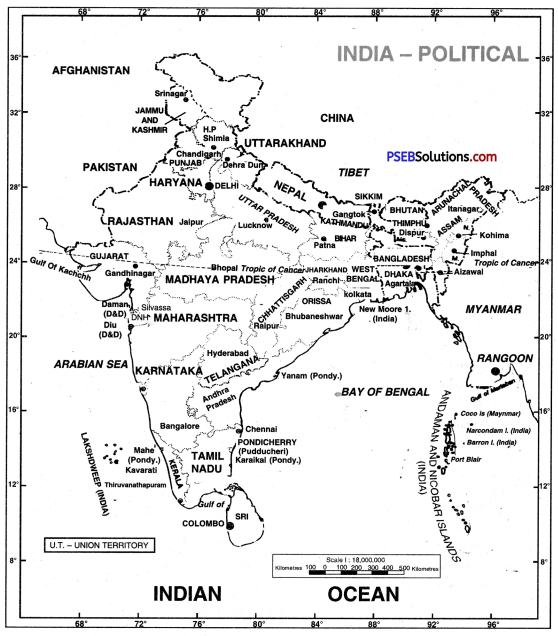
How has India got its name? Describe in detail its size and Administrative divisions.
Answer:
According to ancient writings, the name of our country has been changing. First of all, its name was Himachal Setu Paryantam. It means the area between Himachal and Rameshwarm. With the arrival of Aryans, it was called Aryavarat. According to Rig Veda, it was called Bharatvarsh on the name of Bharat, son of King Dushyant.
The new name ‘India’ is based on the river Indus. The vast river of North West had name Indus (Sindhu). This word Sindhu changed to ‘Hindu’. The people living along this river were called Hindus by the Iranians. The Greeks changed it to Indus and the people were called Indus ; later on it changed to India, Hindustan and Bharat.
Shape and size. Its shape is triangular, with Arabian Sea on one side and Bay of Bengal on the other side. It is broader in the North and tapering toward south. It is a point at Kanyakumari.
Administrative divisions. There are 28 States and 8 Union Territories. In fact, India is a unique country.
![]()
Question 2.
What is the impact of India’s geographical location on its security, climate, trade and culture? (Pb. 2014)
Answer:
India is a vast country situated in South Asia. It occupies a central position at the head of Indian ocean. Its effects are:
1. Defence. India has a strong naval fleet for defence of its long coastline. Its frontiers on the south are safe. Land and Air force is there to defend land frontiers of North. India has faced the attacks from the North, and has helped Sri Lanka and Maldives also.
2. Climate. India enjoys monsoon climate being located between the Himalayas and Indian Ocean. India mostly gets rainfall in summer, but S.E. part gets winter rainfall.
3. Trade. Most of trade routes pass through Indian ocean along the coast of India. These connect India with Europe and America on the west and Australia, East Asia, and Far East.
4. Culture. Different racial groups like Aryans, Greeks, Turks, Mughals came through passes to the N. West and settled in India. These races mixed with Indians and gave a new form to Indian culture. Indian culture got many changes in dress, food and mode of living.
In fact, India has an important position in the world due to its location.
Question 3.
‘India is a country of diversity.’ Explain the statement.
Answer:
India is a land of severe contrasts. The vastnesss has produced a diversity in physical and social conditions.
Factors of Diversity :
1. Vast size of the Indian Sub-continent : India ranks seventh in the world as regards to area. Thus, there is marked regional diversity in natural features.
2. Physical Environment : There is a high degree of diversity in the natural environment of India. Regional differences are found in relief, climate, vegetation and soils. The youthful topography of Himalayas with highest peak of the world, represent a great contrast to the old dissected topography of the Deccan plateau.
3. Ethnic Groups : Different racial groups entered India during different periods. The Mediterraneans, Negritos, Proto-Australoids and the Mongoloids are the main racial groups found in different parts of India.
4. Agriculture : India is primarily an agricultural country. A number of crops are grown ranging from tropical region to temperate region.
Question 4.
Which factors influence the regional disparities found in India?
Answer:
The following factors have created regional diversity in India:
- Vast Size. India is a vast country. North-South extent is 3214 km. while East-West extent is 2933 km. It is impossible to have a uniform relief over a country. It is a land of contrasts.
- Relief. India has a varied relief. It includes mountains, plateaus and plains. It includes narrow valleys as well as deserts.
- Climate. India has a variable rainfall. Some parts get the highest rainfall in the world. Some areas are the desert areas of the world. The Northern part has an extreme climate while Peninsula gets hot climate and coastal areas have a marine climate.
- Migration. Different racial groups entered India from different areas. Mongoloids, Aryans, Muslims, Dravidians settled in India.
- Culture. Due to the settlement of different racial groups, the food, shelter, clothing, mode of living, folk songs, folk dance of festivals and fairs of people are different.
![]()
Question 5.
Which factors are responsible for maintaining India’s unity in diversity?
Answer:
Factors of Unity:
- Monsoons: India has primarily a monsoon type of climate. Seasons follow the pattern of monsoons in India.
- Cultural Fusion: Different cultures are found in different regions. The mixing and exchange of these cultures have led to a cultural fusion in India. It has created a strong bond of integration. Sanskrit and Persian provided strong bonds of unity in the religious, cultural and intellectual fields.
- Economic Factors: The development of inter-regional means of transport and communication has played an important role in unifying the country.
- Languages and Fine Arts: Sanskrit, Urdu, Hindi and English languages have created a unity in India. Fine arts and folk songs represent some feelings of nationalism.
IV. Show the following port on the outline map of Indian subcontinent :
Question 1.
(1) India’s neighbouring countries and their capitals.
(2) Oceans adjoining India.
(3) Standard meridian.
(4) Runn of Kuchchh, Kanyakumari, Arunachal Pradesh, Srinagar.
(5) States and their capitals adjoining Bangladesh.
(6) New Moor Islands, Diu, Lakshadweep, Indira Point.
Answer:
PSEB 10th Class Social Science Guide India: An Introduction Important Questions and Answers
Answer the following questions in one word or one line :
Question 1.
Name the two zones formed by Tropic of Cancer in India.
Answer:
Tropical zone and Temperate zone.
Question 2.
Which line of latitude passes through centre of India?
Answer:
23\(\frac{1}{2}\)°N.
Question 3.
What is the total length of coastline of India?
Answer:
7516 km.
Question 4.
Which ocean route links India with Europe?
Answer:
Suez Canal.
![]()
Question 5.
Which is the smallest state of India?
Answer:
Goa.
Question 6.
Name a group of coral islands.
Answer:
Lakshadweep.
Question 7.
Name a capital town located on tropic of cancer.
Answer:
Gandhinagar.
Question 8.
Name the line forming the boundary between China and India.
Answer:
Mac Mahon line.
Question 9.
Which state is called the ‘Land of dawn’?
Answer:
Arunachal Pradesh.
Question 10.
Name the Southernmost point of India.
Answer:
Indira Point.
Question 11.
Name the place where three seas meet.
Answer:
Kanya Kumari.
Question 12.
Name a Southern neighbour country of India.
Answer:
Sri Lanka.
![]()
Question 13.
Where does India rank in population in world?
Answer:
Second.
Question 14.
Name a state which has the longest coastline.
Answer:
Gujarat.
Question 15.
In which two parts is India divided from the administrative point of view?
Answer:
India is divided into two parts from the view of administration—States and Union Territories.
Question 16.
Write the longitudinal extent of India.
Answer:
The longitudinal extent of India is 68°-7′-33″ to 97°-24′-47” E.
Question 17.
Write the latitudinal extent of India.
Answer:
The latitudinal extent of India is 8°4′ to 37°6′.
Question 18.
How many states and union territories are there in India?
Answer:
There are 28 states and 8 union territories in India.
Question 19.
Which groups of islands of India are situated in the Bay of Bengal and Arabian Sea?
Answer:
Andaman Nicobar and Lakshdweep islands of India are situated in the Bay of Bengal and Arabian Sea.
![]()
Question 20.
In which continent is India situated? How much percentage 6f land area is covered by India?
Answer:
India is situated in the continent of Asia. This country covers the 2.2% of land area.
Question 21.
Name the three states of India along the borders of Pakistan.
Answer:
- Punjab
- Rajasthan
- Gujarat.
Question 22.
Which is the smallest Union Territory?
Answer:
Lakshadweep.
Question 23.
Name the two oceans along India and write the length of its coastal line.
Answer:
The Indian Ocean and the Arabian Sea are oceans along with India. The length of its coastal line is 6,083 km.
Question 24.
Write two characteristics of states of India.
Answer:
- The number of states of India is 28.
- Rajasthan in the area and Uttar Pradesh in population rank first.
Question 25.
Name four union territories of India.
Answer:
Delhi, Chandigarh, Lakshadweep, Puducherry.
Question 26.
Write the East-West and North-South extent of India.
Answer:
The East-West extent of India is 2,933 km. and the North-South extent of India is 3214 km.
![]()
Question 27.
What is the length of coastline and land border?
Answer:
The length of coastline is almost 6,083 km. and the length of land border is almost 15,200 km.
Question 28.
Which strait separates India from Sri Lanka?
Answer:
Palk Strait.
Question 29.
Name any four states of India along the borders of other countries.
Answer:
Punjab, Rajasthan, Gujarat and West Bengal are four states along the borders of other countries.
Question 30.
Which states of India are surrounded by boundaries of five states?
Answer:
Madhya Pradesh and Karnataka.
Question 31.
Write the four states situated on the Eastern coast.
Answer:
The four states situated on the Eastern coast are—Tamil Nadu, Andhra Pradesh, Orissa, West Bengal.
Question 32.
Write four states of India along Arabian Sea.
Answer:
- Gujarat
- Maharashtra
- Karnataka
- Kerala.
Question 33.
Name four states along the borders of Bangladesh.
Answer:
- West Bengal
- Assam
- Meghalaya
- Mizoram.
![]()
Question 34.
Name the three newly organised states of India.
Answer:
The newly organised states of India are—Chhattisgarh, Uttranchal and Jharkhand.
Question 35.
How many states are coastal states?
Answer:
Nine states— Gujarat, Maharashtra, Karnataka, Goa, Kerala, Tamil Nadu, Andhra Pradesh, Odisha, West Bengal.
Question 36.
How many islands are there in Andaman and Nicobar Islands?
Answer:
204
Question 37.
Between which latitudes and longitudes does the Indian subcontinent lies?
Answer:
Between 8°N to 37°N latitudes and 68°E to 97°E longitudes.
Question 38.
Which line of longitudes passes through the middle of India?
Answer:
82/4° E longitudes.
Question 39.
Name the capitals of Chhattisgarh, Uttranchal and Jharkhand states.
Answer:
The capitals of these states are Naya Raipur, Dehradun and Ranchi respectively.
Question 40.
Name the states from which the states of Chhattisgarh, Uttranchal and Jharkhand have been formed.
Answer:
Chhattisgarh from M.P., Uttranchal from U.P. and Jharkhand from Bihar.
Fill in the blanks:
1. Indian ocean lies in the_________of India.
Answer:
South.
2. India is a_______country.
Answer:
Vast
3. In the west of India lies________desert.
Answer:
Thar
4. India has_______States.
Answer:
28
![]()
5. India has______climate.
Answer:
monsoon.
Multiple Choice Questions:
Question 1.
India has Union Territories :
(a) 5
(b) 6
(c) 9
(d) 8.
Answer:
(d) 8.
Question 2.
Sri Lanka is separated from India by:
(a) Suez Canal
(b) Panama Canal
(c) Palk Strait
(d) Gibraltar Strait.
Answer:
(c) Palk Strait
Question 3.
Islands are situated in Arabian Sea :
(a) Lakshadweep
(b) Andaman
(c) Nicobar
(d) Barren.
Answer:
(a) Lakshadweep
Question 4.
Which is the Southernmost point of India?
(a) Kanyakumari
(b) Indira Point
(c) Rameshwarm
(d) Barren Island.
Answer:
(b) Indira Point
Question 5.
India has a coastline of :
(a) 6500 km
(b) 7500 km
(c) 8500 km
(d) 9500 km.
Answer:
(b) 7500 km
![]()
True / False :
Question 1.
There are 28 states and 6 UT’s in India.
Answer:
False
Question 2.
Ranchi is the capital of Chandigarh.
Answer:
False
Question 3.
Indira point is the southernmost point of India.
Answer:
True
Question 4.
Andaman and Nicobar islands are situated in Bay of Bengal.
Answer:
True
Question 5.
Sanskrit language is used to study Vedas.
Answer:
True
Short Answer Type Questions
Question 1.
Describe the size and extent of India.
Answer:
India has an East-West length of 2933 km. while North-South length is 3214 km. The total area of India is 32,87,263 sq. km. Its size is so long as to include 24 countries of western Europe. It covers 2.2% area of the world. It has a coastline of 7516 km. and land frontiers of 15,200 km.
Question 2.
Reason out why the North-South extent of India is larger than its East- West extent even though the country’s latitudinal and longitudinal extent (in degrees) is of the same value (30°).
Answer:
The East-West extent of India is 2933 kilometres, but the North-South extent is 3214 kilometres. Thus, North-South extent is longer than East-West extent by 281 kms. The fact is that the latitudinal extent (29°02′) and the longitudinal extent (29°18′) of the country are almost of the same value. This is due to the spherical shape of the earth. The equator is the longest circle on the earth (one degree of longitude measures 111 km.). But the length of other parallels goes on decreasing from the equator towards the poles due to the curvature of the earth. At 25° latitude, the length of one degree of longitude is 100 kms. Therefore, the East-West extent is shorter than North-South extent in kilometres. The East-West extent for 30° will be reduced by 30 x 10 kms = 300 kms approximately.
![]()
Question 3.
What is the longitudinal extent of India? What are its implications?
Answer:
India extend between 68°7′ E to 97° 25′ E longitudes. The East-West extent is 2933 km. which is roughly l/12th of the circumference of the earth. Thus, India has a longitudinal extent of about 30° longitudes. There is a time lag of 2 hours between the sunrise in the easternmost and the westernmost horizons of India. It means that the sun takes two hours to rise in Saurashtra after it has ri§pn in Arunachal Pradesh. There is a difference of 4 minutes for 1° of longitude. Therefore, there is difference of time of 2 hours (30° × 4 = 120 minutes = 2 hours). It has been suggested to have two standard meridians (instead of one) to reduce time lag to 1 hour.
Question 4.
‘India is a vast country’. Support the fact with three examples.
Answer:
India is a vast country. It is the seventh-largest country of the world. It has a latitudinal and longitudinal extent of about 30°. Its area accounts 2.4 percent of the total geographical area of the world. India has a central location in the Indian ocean.
Question 5.
South of which latitude, tapering of mainland begins? What are its effects?
Answer:
The mainland of India begins to taper South of 22° N latitude. This tapering divides India into two parts—Northern plains and Southern peninsula. It divides Indian Ocean into three sections—Arabian Sea, Indian Ocean and Bay of Bengal.
Question 6.
What is the effect of latitudinal extent on length of day in different parts of the country?
Answer:
India has a latitudinal extent of 30° almost 1/12 of the circumference of the earth. It affects the altitude of sun and inclination of sun’s rays. The differnce between length of day and night is about 6 hours in Kashmir. But the days and nights are almost equal in Kerala.
Question 7.
‘India’s relations through the land routes are much older than her maritime contacts.’ Discuss.
Answer:
India has a central location in Asia due to her Trans-Indian ocean routes and land routes in the west. The various passes across the mountains in the North have provided passages to ancient travellers. But the oceans restricted such contacts. The land routes helped to make contacts with West Asia.
![]()
Question 8.
Name the five countries whose frontiers meet at the northern apex of India.
Answer:
On the northern side of India, the boundaries of the following five countries meet together: China, Russia, Tajakistan, Afghanistan and Pakistan. These five countries meet at the apex of the north Indian triangle.
Long Answer Type Questions
Question 1.
Into how many divisions, can India be divided on the administrative basis? Explain with the help of a table.
Answer:
India is divided into two parts:
- States.
- Union Territories.
The states are 28 in number and U.Ts. are 8 in number. The names of their capitals and area is given below:
| State | Area (sq. km.) | Capital |
| 1. Andhra Pradesh | 160203 | Amravati |
| 2. Arunachal Pradesh | 81,578 | Itanagar |
| 3. Assam | 78,523 | Dispur |
| 4. Bihar | 94,162 | Patna |
| 5. Chhattisgarh | 1,35,133 | Raipur |
| 6. Goa | 3,702 | Panaji |
| 7. Gujarat | 1,95,984 | Gandhinagar – |
| 8. Haryana | 44,222 | Chandigarh |
| 9. Himachal Pradesh | 55,673 | Shimla |
| 10. Jharkhand | 79,714 | Ranchi |
| 11. Karnataka | 1,91,773 | Bangalore |
| 12. Kerala | 38,864 | Thiruvanthapuram |
| 13. Madhya Pradesh | 3,08,313 | Bhopal |
| 14. Maharashtra | 3,07,762 | Mumbai |
| 15. Manipur | 22,356 | Imphal |
| 16. Meghalaya | 22,489 | Shillong |
| 17. Mizoram | 21,087 | Aizawl |
| 18. Nagaland | 16,527 | Kohima |
| 19. Orissa | 1,55,782 | Bhubaneshwar |
| 20. Punjab | 50,362 | Chandigarh |
| 21. Rajasthan | 3,42,214 | Jaipur |
| 22. Sikkim | 7,299 | Gangtok |
| 23. Tamil Nadu | 1,30,069 | Chennai |
| 24. Tripura | 10,477 | Agartala |
| 25. Uttar Pradesh | 2,38,568 | Lucknow |
| 26. West Bengal | 87,353 | Kolkata |
| 27. Uttranchal | 55,845 | Dehradun |
| 28. Telangana | 114,840 | Hyderabad |
| Union Territories | Area (sq. km.) | Capital |
| 1. Andaman and Nicobar
islands |
8,293 | Port Blair |
| 2. Chandigarh | 114 | Chandigarh |
| 3. Dadra & Nag&r Haveli and Daman and Diu | 491 + 102 | Daman |
| 4. Lakshadweep | 32 | Kavaratti |
| 5. Pondicherry | 48 | Pondicherry |
| 6. Delhi | 1,485 | Delhi |
| 7. Jammu & Kashmir | — | Srinagar |
| 8. Ladakh | — | Leh |
| All India | 32,88,015 | New Delhi |