Punjab State Board PSEB 10th Class Social Science Book Solutions Geography Chapter 3 The Climate Textbook Exercise Questions and Answers.
PSEB Solutions for Class 10 Social Science Geography Chapter 3 The Climate
SST Guide for Class 10 PSEB Land Textbook Questions and Answers
I. Answer the following questions in brief:
Question 1.
Distinguish between climate and weather.
Answer:
Climate. Climate is the description of atmospheric conditions of an area over a long period, (say 35 years) Weather. Weather is the sum total of atmospheric conditions at any place at any specific period.
Question 2.
Name the factors which affect the climate of India.
Answer:
- Distance from the Equator
- Relief
- Pressure system
- Seasonal winds and
- Nearness from the Indian ocean.
Question 3.
Name the places in India having maximum and minimum temperatures during winter season.
Answer:
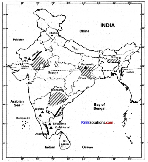
Places with highest temperature Barmer, Jodhpur. Places with lowest temperature Dras, Kargil.
Question 4.
Give the names of hottest and coldest places in India during various seasons.
Answer:
Coldest place: Hilly Areas like Leh and Shillong.
Hottest place: North West plain areas.
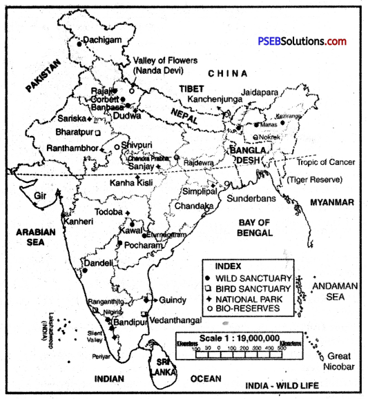
![]()
Question 5.
Name the driest and wettest regions of the country.
Answer:
The driest places of the country are: Leh, Jodhpur, Delhi while Shillong, Mumbai, Kolkata and Trivandrum are the wettest areas.
Question 6.
Name two places in India having moderate and extreme climate.
Answer:
Mumbai and Chennai are two places of equable climate. Extreme climate is found in Amritsar and Jodhpur.
Question 7.
What is the importance of relief in determining the climate?
Answer:
It provides monsoon climate to whole country by acting as a climatic divide.
Question 8.
What is Jet Stream?
Answer:
Jet streams are high velocity winds at high altitudes. A jet stream is a narrow tubular shaped flow of wind along the troposphere. These have a velocity of 500 kms per hour and are located at 5 to 12 kms with an average location between 20°S to 40°N latitudes.
Question 9.
What do you mean by the term Monsoon?
Answer:
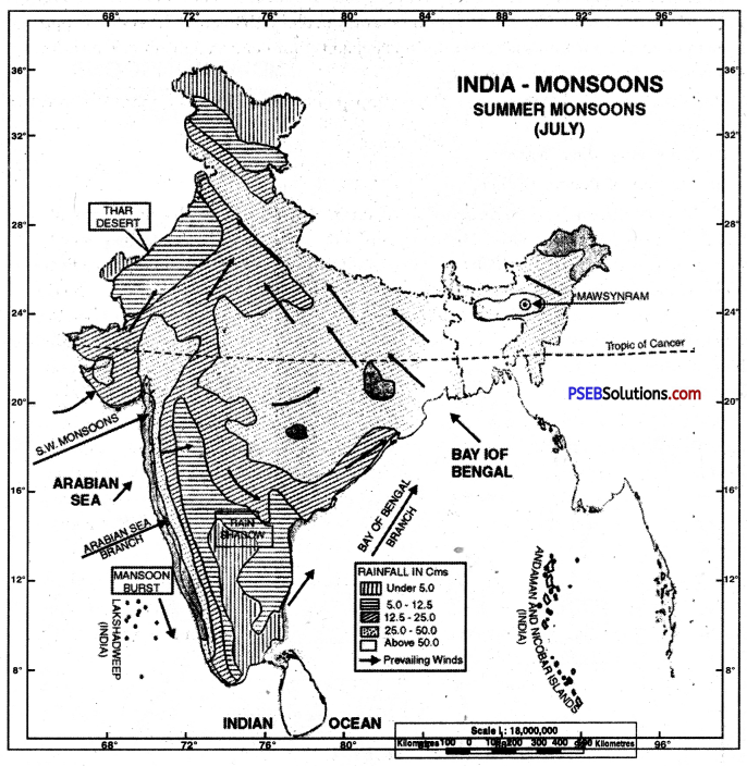
The word Monsoon is said to be derived from the Arabic word ‘Mausam’ meaning season. This word was first applied to the winds blowing over the Arabian sea. Monsoon implies seasonal reversal of the wind pattern over the years. Monsoon winds are those seasonal or periodic winds which changes their direction with the season. These winds blow from sea to land of six months during summer and from land to see during winter. Thus with the change of season the pattern of winds, temperature and rainfall changes.
Question 10.
What is Burst of Monsoons?
Answer:
The monsoon winds blow in south-west direction on the west coast. These are highly charged with water vapour. I’; advances rapidly over west coast. The rains begin rather suddenly in the first week of June. This sudden onset of rain is often termed as ‘Monsoon Burst’. This rainfall is heavily accompanied by thunder and lighting. The rain is so sudden and heavy that it appears as if a balloon of water has been burst.
![]()
Question 11.
What do you mean by ‘Loo’?
Answer:
Loos are hot dusty winds caused by low pressure in hot season. These are very hot and dry winds. These are called ‘Loo’ in local language.
Question 12.
What is Break in Monsoons?
Answer:
The dry period between monsoons is called Break.
Question 13.
What are monsoons?
Answer:
Monsoons are seasonal winds.
Question 14.
Where does ELNINO ocean current flow?
Answer:
Elnino current flows along the coast of Chile. It is studied for the reasons causing Monsoon.
Question 15.
What are ‘Kal Baisakhis’ or Norwesters?
Or
What are Kal Baisakhis?
Answer:
The destructive cyclones are called Kal Baisakhis in West Bengal.
Question 16.
What is meant by ‘Mango Shower’?
Answer:
North East Monsoons give rain in coastal areas of Kerala and Karnataka at the end of summer seasons.
![]()
Question 17.
At which places do the Monsoon winds coming from Arabian Sea and Bay of Bengal meet?
Answer:
The Monsoon winds from Arabian Sea and Bay of Bengal meet in Punjab and Himachal Pradesh.
II. Give reasons df the following in brief:
Question 1.
Mumbai is colder than Nagpur.
Answer:
Nagpur is situated away from sea. Whereas Mumbai is situated on the sea shore. There is equable type of climate in Mumbai due to effect of sea. Therefore there is less cold.
In the opposite of it, Nagpur has situated far away hum sea and free from sea effect. Therefore, extreme type of climate is found here.
Therefore, Nagpur is colder than Mumbai in winter.
Question 2.
Most of the average Annual rainfall in India comps in just four months of the year.
Answer:
In India, rainfalls mostly from mid June to mid September. The Monsoon winds coming from sea blow oyer India in these four months. These vapour laden winds give heavy rainfall in India.
Question 3.
Kolkata receives 145 cm of Rainfall whereas Jaisalmer receives only 12 cm of rainfall by the South West monsoons.
Answer:
The S. W. monsoons, from Bay of Bengal, first of all strike in Kolkata in West Bengal. These moisture laden winds give a heavy rainfall of 145 cms here. Jaisalmer lies to the west of Aravallis in Rajasthan. Aravallis lie parallel to S.W. Monsoons of Arabian sea. So these mountains fail to check S. W. monsoons. These winds move northward giving only 12 cms of rainfall.
![]()
Question 4.
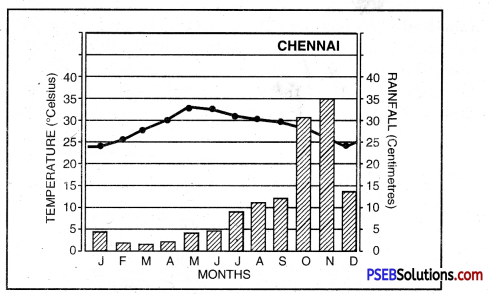
Chennai receives most rainfall during winter season.
Answer:
Chennai is situated on Eastern coastal plain of India. It comes under the effect of North-East monsoon winds. These winds move from land to sea. But while crossing the Bay of Bengal, these pick up moisture. After striking Eastern ghats, these give heavy rainfall in winter. In summer, it gets less rain as it is a rain shadow area.
Question 5.
Chennai gets more rainfall in winters. Why?
Answer:
Chennai is located on the east coast of India. N.E. monsoons give here rainfall in winter. But in summer, dry winds blow which do not give more rainfall.
III. Answer the following questions in short:
Question 1.
What are the regional variations in the climate of India?
Answer:
- Range of Temperature. There is a great variation in range of temperatures in different parts of India. Kerala and Andaman-Nicobar islands have a daily range of temperature i. e. 8° C. On the other hand in Thar Desert, if the day temperature is around 50° C, at night it may drop down very close to freezing point (0°C). The daily range of temperature is 50°C.
- Direction of Rain Bearing Winds. Most of India gets rain in summer from S. W. Monsoons but, in winter Tamilnadu gets rain from N. E. Monsoons.
- Form of Precipitation. Most of the country gets rain showers, while snowfall occurs in the Himalayas.
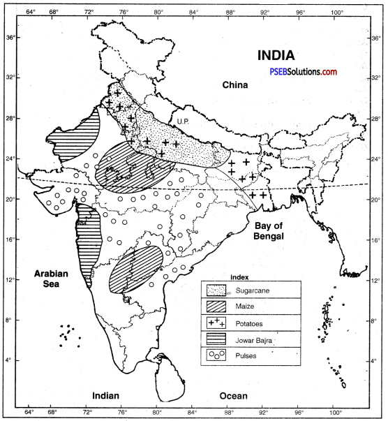
- Amount of Rainfall. The annual rainfall is less than 10 cms in N. W. Himalayas and Thar Desert. It exceeds 400 cms. in Meghalaya. Mawsynram gets 1,141 cms rainfall.
- Rainfall Regime i.e. Seasonal Distribution of Rainfall. There is a great variation in rainfall regimes in the country. Most of the country gets rain from advancing monsoons in summer. Tamilnadu gets rainfall in winter from N.E. monsoons. Some parts receive rainfall from retreating monsoons.
Question 2.
Give an account of the main reasons for the climatic variations in the country.
Answer:
There are great variations in the climate of India. It is not the same throughout the year due to:
- Northern hilly region remains cold due to high altitude. Coastal areas have equable climate. Interior areas have high temperatures.
- Windward slopes get high rainfall but rain shadow areas are dry.
- In summer, winds blow from sea, to land. These moist winds give heavy rainfall. But as these move ahead, the rainfall goes on decreasing.
- In winter the winds blow from land to sea. These winds are dry. Only S.E. coast of India gets rainfall. Other parts remain dry.
Question 3.
Why does the Pre-Monsoonal rainfall occur?
Answer:
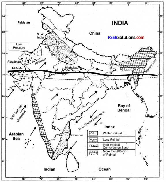
In summer, equatorial low-pressure shifts towards Tropic of Cancer. To fill this space, the S.E. trades cross the Equator and get the direction of S.W. winds due to rotation of the earth. On 1st June, when these winds reach west coast, moderate rainfall occurs on windward slope of western ghats. This is called pre-monsoonal rainfall.
Question 4.
Describe India’s rainy season.
Answer:
Rainy season is also called the South West Monsoon season. Its time period is from the June to Mid September. The main characteristics of this season are:
- A low pressure trough is developed in N.W. India.
- Winds enter into the country from sea and give heavy rainfall.
- The winds filled with humidity move at the rate of 30 km per hour and spread into whole country within one month.
- Indian peninsula divides Monsoon into two parts-Monsoon winds of Arabian Sea and Monsoon winds of Bay of Bengal.
- Most of rainfall in Western ghat and North East area of India is done by monsoon winds of Bay of Bengal.
There is more than 250 cm of rainfall on the winward slopes of western ghats. On the opposite there is more than 50 cm of rainfall on leeward slopes. Therefore due to this reason most of rainfall in Northeast states of India is highest and longer on hills of Eastern Himalayas. On the opposite the amount of rainfall goes on decreasing from East to West.
Question 5.
Which places receive maximum rainfall in India?
Answer:
The areas in which the rainfall is between from 1.50 to 200 cm are the places with highest rainfall. These are divided into three areas:
- A narrow belt of 20 km width extends from western ghat to Kanyakumari in the North-South direction. It extends from the mouth of the Tapti River to the plains of Kerala.
- Second belt extends along the southern slopes of Himalayas. It extends from Himachal Pradesh to the valley of Assam passing through Kumaon Himalaya.
- Third belt extends in North-South direction. The hills of Tripura, Manipur and Mekar are in it. There is 200 cm annual rainfall in the belt.
![]()
Question 6.
Give any three characteristics of Indian Monsoon.
Answer:
See Question 2. Part IV.
Question 7.
In spite of being close to the Arabian Sea, why does Rajasthan remain dry?
Or
Why Rajasthan remains dry inspite of being close to Arabian Sea?
Answer:
The western part of Rajasthan is desert. It gets an annual rainfall less than 20 cms. This is due to the following reasons:
- Rajasthan is under the influence of S.W. summer monsoons. The Aravallis system lies parallel to the direction of S.W. monsoons coming from Arabian Sea. So this mountain system is unable to check these winds. So western Rajasthan is practically dry. The southern part gets some rainfall.
- This area lies at a great distance from the Bay of Bengal. The Bay of Bengal monsoons become dry and lose their moisture when they reach Rajasthan.
- This area is away from the Himalayan region. So it does not come under the influence of monsoons giving rain in Sub-Himalayan region.
Question 8.
How do South East trade winds cause Monsoon rainfall?
Answer:
South East trade winds crossing the equator move towards India. The direction is changed due to rotation and move in S. W. directions. These reach Kerala coast on 1st June and give heavy rainfall. This is called Monsoon burst. These winds cover whole of India in one month and give rainfall.
IV. Answer the following questions subjectively:
Question 1.
Which elements affect the climate of India?
Answer:
The climate of India is mainly based on the following facts:
1. Distance from the equator. The places which are situated near the equator have high temperature whereas the places away from the equator do not have high temperature.
2. Height above sea level. The higher you go, the cooler it is. That is why the mountainous regions are cooler than plains.
3. Distance from the sea. The places near the sea have equable climate. Neither the summers are very hot nor the winters are cold, whereas in the parts away from the sea the summers are hot and winters are cold.
4. Winds. The winds have a great affect on the climate of India. The winds coming from the sea are full of moisture and they cause heavy rain. On the other hand, the winds that come from the land are dry winds and cause no rain.
5. Direction of the mountains. Wherever the mountains are located in the way of the winds, the winds are forced to rise against the mountains and cause rainfall. For example, when the moisture laden monsoon winds strike against Himalayas they cause heavy rain in West Bengal and Assam. On the other hand, the Aravali mountains run parallel to the direction of the monsoons that blow from the Arabian Sea and there is no rain in Rajasthan.
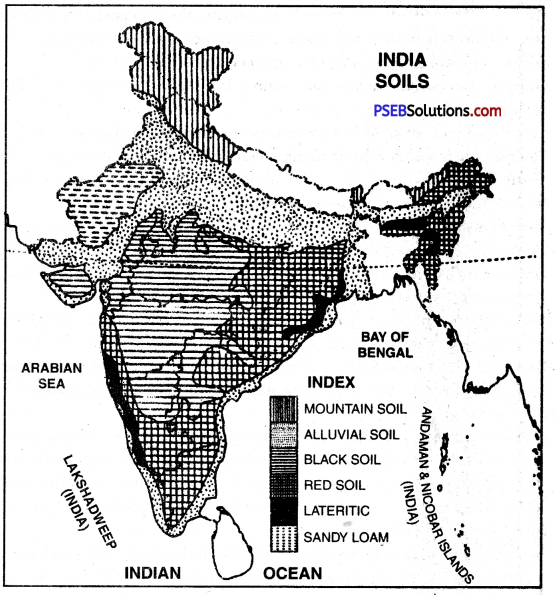
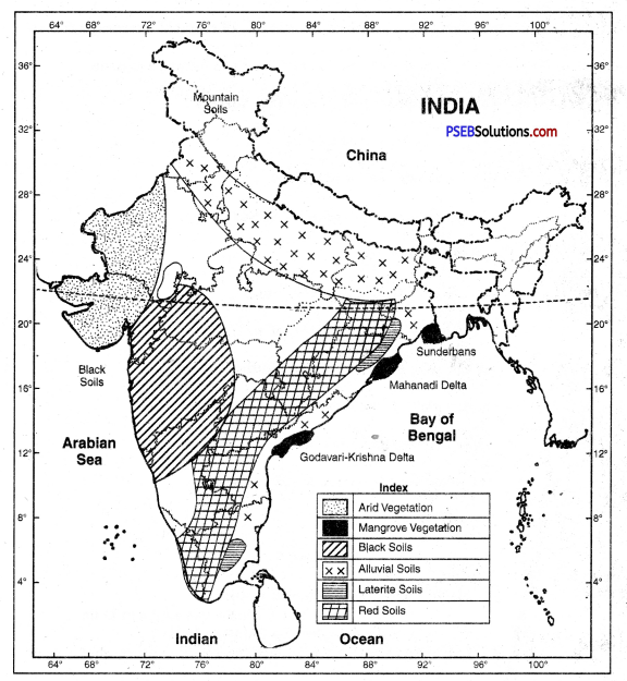
6. Nature of the soil. Sand gets heated and cooled quickly. The land is sandy in Rajasthan. That is why, the temperature is of extreme type there.
7. Slope of the land. If the land slopes towards the sun the rays of the sun will fall vertically and the temperature will be high. On the contrary if the land slopes away from the sun the rays of the sun will be slanting and the temperature will be low.
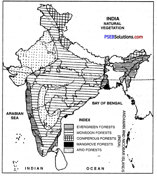
8. Forests. The regions with dense forests receive heavy rain, because the winds blowing over these forests gain moisture from the leaves of the trees, lose temperature and cause rain.
![]()
Question 2.
Describe the main characteristics of monsoon rainfall in India.
Answer:
Characteristics of rainfall in India: The average annual rainfall in India is about 110 cms. It is estimated that more than 85% of this rainfall is received in summer. The main characteristics of summer rainfall are given below:
- Monsoonal rainfall. Most of the rain is received from S.W. summer monsoons during the period mid-June to mid-September. It is seasonal rainfall.
- Uncertain rainfall. Summer rainfall is quite uncertain. Some times monsoons start early resulting in floods. Often the onset of monsoons is delayed resulting in drought. The early or late retreat of monsoons also results in serious droughts.
- Unequal distribution. The rainfall is Unevenly distributed over the country. About 10% of the country gets more than 200 cms of rain while 25% of the country gets less than 75 cms of rain.
- Heavy rainfall. Indian rainfall is heavy and downpouring type. It is often said, “It pours, it never rains in India.”
- Relief rainfall. The amount of rainfall is determined by the presence of mountains. High mountains force monsoons to rise and cause rain.
- No continuity of rainfall. Summer rain is characterised by breaks or dry spells.
- Variable rainfall. Most of the areas have variable rainfall, as much as 30 cms. plus or minus. Due to variability in areas of low rain, famines occur.
Question 3.
Explain the characteristics of different seasons of India.
Answer:
The Indian Weather: The Indian sub-continent has a tropical monsoon climate. Monsoons dominate the climate of the sub-continent. Monsoons exercise a unifying influence on the weather conditions of India making it a single meteorological unit. India has a broad unity of monsoon type of climate having the same rhythm of season. The advance and retreat of monsoon divide the weather into different seasons.
(A) Seasons of N.E. Monsoons.
- The Cold Season. December to February.
- The Hot Season. March to May.
(B) Season of S.W. Monsoons.
- The Rainy Season. June to September
- The Season of Retreating Monsoon. October to November.
1. The Cold Season: The cold season lasts from December to February.
(a) Temperature. The sun is overhead at Tropic of Capricorn. The Indian sub-continent has winter season. January is the coldest month. The southern parts have warm conditions. (20°C) while low temperatures (10°C) are found in N.W. India.
(b) Pressure and Winds. High pressure is developed over N.W. part while a low pressure exists over the Indian Ocean with the result winds blow from land to sea. The out-blowing winds are Westerly in Northern plain and North Easterly over the rest of the country.
Rainfall. The N.E. Monsoons are off-shore winds and are dry. But these winds pick up some moisture crossing Bay of Bengal and give rain to S.E. coast of India. Some cyclones from Mediterranean Sea also bring a small amount of rain (10 to 20 cms.) to Northern plains. Night Frost is common in the N.W. parts.
2. The Hot Season. The hot season lasts from March to May.
(а) Temperature: As the sun’s rays fall vertical over Tropic of Cancer, the temperature begins to rise. The average temperature is above 30 C; the maximum temperature rises to 50°C in Banner (Rajasthan). The daily range of temperature rises in inland areas.
(b) Pressure and Winds. Intense heat results in the development of low pressure over N.W. India and Pakistan. A high pressure exists over Indian Ocean. S.W. Monsoons begin to blow from sea to land. ‘Norwesters’ and ‘Loo’ blow over Northern plains.
(c) Rainfall. Some areas receive convectional rainfall. The west coast also starts receiving rainfall. Most of the country is dry in the pre-Monsoon period.
3. The Rainy Season. The rainy season lasts from June to September.
(а) Temperature. The sun shines vertical over Tropic of Cancer. The temperatures are more than 30°C. With the onset of monsoon, there is a drop in temperature (5° to 10°C) with the result July is not the hottest month.
(b) Pressure and Winds. S.W. Monsoons blow from sea to land with a “burst’ on the West coast. It blows in two currents.
- The Arabian Sea Current,
- The Bay of Bengal Current
(c) Rainfall. S.W. Monsoons are rain giver as most of the sub-continent gets rainfall in this season. The Arabian Sea branch gives heavy rainfall on the West Coast, but Deccan plateau lies in rain shadow of Western Ghats. The Bay of Bengal branch gives heavy rainfall in Eastern Himalayas. The rainfall goes on decreasing up the Ganges valley with the decrease in moisture. Rajasthan is practically a desert.
4. The Season of Retreating Monsoon. S.W. Monsoons begin to withdraw from the sub-continent during the first week of October. The sun begins to move towards equator. There is a decrease in temperature. Hot and sticky weather is found. Some tropical cyclones are developed which give heavy rainfall in coastal areas. Cool-weather begins in N.W. India, but the Southern parts have an equable climate.
![]()
Question 4.
Compare the summer and winter seasons of India.
Answer:
The Indian Weather: The Indian sub-continent has a tropical monsoon climate. Monsoons dominate the climate of the sub-continent. Monsoons exercise a unifying influence on the weather conditions of India making it a single meteorological unit. India has a broad unity of monsoon type of climate having the same rhythm of season. The advance and retreat of monsoon divide the weather into different seasons.
(A) Seasons of N.E. Monsoons.
- The Cold Season. December to February.
- The Hot Season. March to May.
(B) Season of S.W. Monsoons.
- The Rainy Season. June to September
- The Season of Retreating Monsoon. October to November.
1. The Cold Season: The cold season lasts from December to February.
(a) Temperature. The sun is overhead at Tropic of Capricorn. The Indian sub-continent has winter season. January is the coldest month. The southern parts have warm conditions. (20°C) while low temperatures (10°C) are found in N.W. India.
(b) Pressure and Winds. High pressure is developed over N.W. part while a low pressure exists over the Indian Ocean with the result winds blow from land to sea. The out-blowing winds are Westerly in Northern plain and North Easterly over the rest of the country.
Rainfall. The N.E. Monsoons are off-shore winds and are dry. But these winds pick up some moisture crossing Bay of Bengal and give rain to S.E. coast of India. Some cyclones from Mediterranean Sea also bring a small amount of rain (10 to 20 cms.) to Northern plains. Night Frost is common in the N.W. parts.
2. The Hot Season. The hot season lasts from March to May.
(а) Temperature: As the sun’s rays fall vertical over Tropic of Cancer, the temperature begins to rise. The average temperature is above 30 C; the maximum temperature rises to 50°C in Banner (Rajasthan). The daily range of temperature rises in inland areas.
(b) Pressure and Winds. Intense heat results in the development of low pressure over N.W. India and Pakistan. A high pressure exists over Indian Ocean. S.W. Monsoons begin to blow from sea to land. ‘Norwesters’ and ‘Loo’ blow over Northern plains.
(c) Rainfall. Some areas receive convectional rainfall. The west coast also starts receiving rainfall. Most of the country is dry in the pre-Monsoon period.
3. The Rainy Season. The rainy season lasts from June to September.
(а) Temperature. The sun shines vertical over Tropic of Cancer. The temperatures are more than 30°C. With the onset of monsoon, there is a drop in temperature (5° to 10°C) with the result July is not the hottest month.
(b) Pressure and Winds. S.W. Monsoons blow from sea to land with a “burst’ on the West coast. It blows in two currents.
- The Arabian Sea Current,
- The Bay of Bengal Current
(c) Rainfall. S.W. Monsoons are rain giver as most of the sub-continent gets rainfall in this season. The Arabian Sea branch gives heavy rainfall on the West Coast, but Deccan plateau lies in rain shadow of Western Ghats. The Bay of Bengal branch gives heavy rainfall in Eastern Himalayas. The rainfall goes on decreasing up the Ganges valley with the decrease in moisture. Rajasthan is practically a desert.
4. The Season of Retreating Monsoon. S.W. Monsoons begin to withdraw from the sub-continent during the first week of October. The sun begins to move towards equator. There is a decrease in temperature. Hot and sticky weather is found. Some tropical cyclones are developed which give heavy rainfall in coastal areas. Cool-weather begins in N.W. India, but the Southern parts have an equable climate.
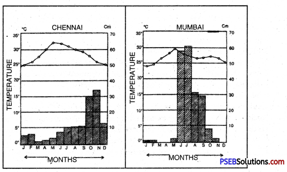
Climatic graphs of Chennai and Mumbai
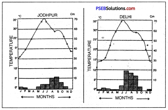
Climatic graphs of Jodhpur and Dethi
![]()
Question 5.
Explain with the help of examples the impact of monsoon winds on life in India.
Answer:
Climate has a great effect on the economic, religious and social life of a country. It is also true in case of India. Monsoon is a powerful element of the climate of India and affects the life of people in many ways:
1. Economic effects. A lot of people depend upon agriculture. Monsoon rains are the basis of agriculture and backbone of the Indian Economy. If monsoons occur in time, it helps to increase agricultural production. When monsoons fail, there is a drought in India and the foodgrain reserves decrease. If monsoons start earlier,
the floods occur in different parts. If monsoons start late, the crops fail. With the result, it is often said, Indian budget is a gamble in monsoons.
2. Social effects. Monsoons affect the food, clothing, customs of people. With the
start of Monsoons, dress of people changes due to change in temperature. Monsoon winds complete a cycle in the country in which food and clothings change turn by turn. .
3. Religious effects. Many festivals are connected with monsoons. The sowing of crops and harvesting of crops are connected with festivals. Baisakhi in Punjab marks the harvesting of wheat crop and Bhangra is performed by farmers. In fact, the life of Indians revolves around Monsoons.
![]()
Question 6.
In spite of vast monsoon unity, there exist wide regional disparities in India. Explain with examples.
Answer:
The rainfall is unevenly distributed in India. Many regional variations are found in the distribution of annual rainfall. The distribution of annual rainfall shows two main trends:
- From the coastal areas, the rainfall decreases towards the west and North-West.
- The rainfall decreases towards the interior of the country.
The main factors controlling this distribution of rainfall are the presence of high mountains and the distance from the sea. The coastal areas get high rainfall. The west coast gets more than 200 cms. of rainfall while the east coast gets about 100 cms. of rainfall. The rainfall in the interior of peninsular India is as low as 50 cms. The Western Ghats, the Garo-Khasi hills, and the Sub-Himalayan region get more than 200 cms. of rainfall. But Rajasthan is dry as there is no high mountain to check S.W. Monsoons.
Distribution of Rainfall, The average annual rainfall of India is 118 cms. Regional variations in the distribution are found due to differences in relief of the country. Rainfall is unevenly distributed throughout the country.
India can be divided into the following, rainfall regions:
- Areas of Heavy Rainfall. These areas get more than 200 cms. of annual rainfall. These include Western Coast and Western Ghats, Sub-Himalayas and the N.E. parts of India.
- Areas of Moderate Rainfall. These areas get annual rainfall of 100-200 cms. These include West Bengal, Orissa, Bihar, Eastern parts of U.P. and Madhya Pradesh and coastal plains of Tamilnadu.
- Areas of Low Rainfall. These areas experience an annual rainfall of 50-100 cms. These include Uttranchal, Haryana, Punjab, Gujarat, Peninsular plateau and Eastern Rajasthan.
- Areas of Scanty Rainfall. These areas get less than 50 cms. of annual rainfall. These include Ladakh, S.W. Punjab, Southern Haryana, Western Rajasthan, Kutch and Thar Desert.
IV. Represent the following on the outline map of India.
Question 1.
(i) Low pressure areas of summer and direction of winds.
(ii) Areas of winter rainfall and direction of North-East monsoon winds.
(iii) Cheerapunji, Jaiselmer, Allahabad, Chennai.
(iv) Regions of very less rainfall.
(v) Regions of more than 200 centimetres rainfall.
Answer:
PSEB 10th Class Social Science Guide The Climate Important Questions and Answers
Answer the following questions each in one word or one line:
Question 1.
Which type of climate is found in India
Answer:
Monsoon climate.
Question 2.
Name the hottest place in India.
Answer:
Barmer.
Question 3.
Name the coldest place in India.
Answer:
Dras.
![]()
Question 4.
Name the Rainiest place in India.
Answer:
Mawsynram.
Question 5.
What is the cause of winter rain in’ Punjab?
Answer:
Cyclones.
Question 6.
What type of winds are monsoons?
Answer:
Seasonal.
Question 7.
What is the direction of summer monsoons?
Answer:
South-west.
Question 8.
Name a Kharif crop depending on rains.
Answer:
Rice.
Question 9.
What are hot dusty winds?
Answer:
Loo.
Question 10.
Name one example of rain shadow.
Answer:
Deccan plateau.
Question 11.
For which crop mango shower is useful?
Answer:
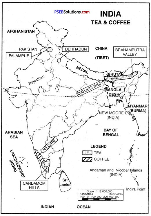
Coffee.
Question 12.
Which region has high pressure in winter?
Answer:
Rajasthan.
Question 13.
To which state Kal Baishaki relates?
Answer:
Assam.
![]()
Question 14.
For which crop,winter rainfall is useful?
Answer:
Wheat.
Question 15.
What is the duration of monsoon in India?
Answer:
120 days.
Question 16.
How do Arabian Sea and Bay of Bengal affect the climate of Sub¬continent?
Answer:
These two affect very deeply the climate of Indian sub-continent.
Question 17.
Which land mass works as effective climatic divide for India and how?
Answer:
Great Himalayas work as an effective climate divide for India.
Question 18.
If there were no monsoons what will be effect on India’s land mass?
Answer:
If there were no monsoons in India then it will become a dry land mass or a desert.
Question 19.
How do mountain ranges of Himalaya effect the extent of monsoons in India?
Answer:
Due to their effect the whole Indian sub-continent comes under the effect of saturated winds.
Question 20.
What is the period of rainy season in India? How much percentage rainfall occurs in this period?
Answer:
The period of rainy season is from June to September. 75% to 90% of rainfall occurs in this period.
Question 21.
In which part of India rainfall occurs by Western Cyclones? For which crop this rainfall is useful?
Answer:
Rainfall occurs in the northern India by western cyclones. This rainfall is useful for Rabi crop, especially the crop of wheat.
Question 22.
What is Monsoon trough?
Answer:
Monsoon trough is the name given to the region in the inter tropical convergence zone which has low pressure.
![]()
Question 23.
What do you mean by low pressure trough of Monsoon?
Answer:
The area with low pressure air develops in a big area in the end of May in this area.
Question 24.
Write two characteristics of Monsoon.
Answer:
- Monsoon winds change their direction with the change in season.
- Rainfall occurs in the rainy season due to these winds.
Question 25.
Write two main characteristics of season of Retreating winds.
Answer:
- The area of low pressure is replaced by high pressure air.
- Monsoons withdraw from Northern plains by the end of October.
Question 26.
In which part of India is the highest temperature in the start of summer season and what is the temperature?
Answer:
There is highest temperature on Deccan Plateau in the start of summer season and the temperature is almost 38°C.
Question 27.
Which place has the highest rainfall in the world and why?
Answer:
The highest rainfall occurs in the Mawsynram in the world.
Question 28.
Why does Shillong get more rainfall than Kolkata?
Answer:
Shillong is situated at high altitude in Meghalaya. Bay of Bengal branch gives here heavy rainfall (about 400 cms annual rainfall).
Question 29.
Why has Thiruvananthapuram an equable climate?
Answer:
Thiruvananthapuram is a coastal town of Kerala.
Question 30.
Define two characteristics of cold season in India.
Answer:
- The cold season occurs during December, January and February.
- It has a pleasant, comfortable weather.
![]()
Question 31.
Why does Thar desert get low rainfall?
Answer:
Aravallis lie parallel to S.W. monsoons and fail to check monsoons.
Question 32.
Name the following:
(i) Two stations affected most by Arabian Sea Branch of Monsoons.
Answer:
Windward slope of West ghats, and coastal plain
(ii) The most affected place by Bay of Bengal Branch of Monsoons.
Answer:
Mawsynram, Cheerapunji
(iii) Two stations affected by both.
Answer:
Dharamsala, Mandi (H.P.).
Question 33.
Name the following:
(i) Two stations affected by Retreating monsoons & N.E. monsoons.
Answer:
Chennai and Madurai
(ii) The months with highest rainfall.
Answer:
July, August.
![]()
Question 34.
Mumbai gets most of rainfall in summer, while Chennai gets most of rainfall in winter. Why?
Answer:
- Mumbai gets rainfall by onshore S.W. winds of Arabian Sea.
- Onshore N.E. winds give rainfall in winter season.
Question 35.
What is meant by Rain Shadow?
Answer:
The leeward dry slope of mountain.
Question 36.
Name the rainiest place in India.
Answer:
Mawsynram near Cheerapunji – 1187 cm rainfall.
Fill in the blanks:
Question 1.
Tropic of________ bisects India.
Answer:
Cancer
Question 2.
_______ % rain falls in summer.
Answer:
87
Question 3.
Agriculture is based on _________
Answer:
Monsoons
![]()
Question 4.
The west coast gets rainfall of ________
Answer:
250 cms
Question 5.
Hot season is __________
Answer:
dry
Multiple Choice Questions:
Question 1.
Which is the coldest place in India?
(a) Srinagar
(b) Shinila
(c) Dras
(d) Shillong.
Answer:
(c) Dras
Question 2.
Which is the hottest place in India?
(a) Nagpur
(b) Bangalore
(c) Barmer
(d) Kanpur.
Answer:
(c) Barmer
Question 3.
Which is the rainiest place in India?
(a) Cherrapunji
(b) Mawsynram
(c) Kolkata
(d) Mumbai.
Answer:
(b) Mawsynram
Question 4.
The duration of monsoons in India is:
(a) 60 days
(b) 90 days
(c) 120 days
(d) 150 days.
Answer:
(c) 120 days
![]()
Question 5.
Which is a rain shadow area?
(a) Deccan plateau
(b) Assam
(c) Gujarat
(d) Kerala.
Answer:
(a) Deccan plateau
True / False:
Question 1.
The southern part of west coastal plain is called Malabar coast.
Answer:
True
Question 2.
Along the coast of Australia, EL Nino flows.
Answer:
False
Question 3.
Winter cyclonic rainfall helps the growth of wheat crop.
Answer:
True
Question 4.
Dry temperature in June in Barmer is 30°C.
Answer:
False
![]()
Question 5.
Dras is the coldest place in India.
Answer:
True
Short Answer Type Questions
Question 1.
How do Himalayas act as ‘climatic divide’ for India?
Answer:
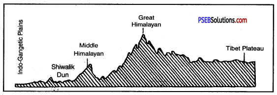
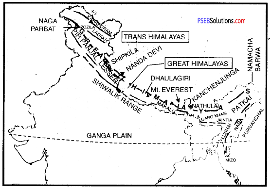
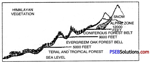
The Himalayas act as a mountain wall to protect the sub-continent from the northern winds. These cold chilly polar winds cannot enter India, as these cannot cross the lofty Himalayas. So these mountains enable the Northern India to have a tropical climate. Thus the Himalayas act as an effective climatic divide.
Question 2.
Describe the origin of Monsoons and cause of its reversal of direction.
Answer:
Monsoon winds are caused due to difference in heating and cooling of land and water. In summer, the land gets more heated than sea resulting in a low pressure on the landmasses and a high pressure over seas. The winds blow from Sea to Land and in winter, from Land to Sea. Thus there is a reversal of wind direction according to seasons.
Question 3.
Distinguish between Western Jet Stream and Eastern Jet Stream.
Answer:
Western Jet Stream. The western jet stream is located in lower stratosphere over Southern Himalayas. In summer, its location is about 30° North. It lies north of the Tien Shan mountains in June.
Eastern Jet Stream. It lies over 25°N latitudes in winter. The western jet stream shifts southward due to shifting of the sun and takes the form of eastern jet stream. It is responsible for sudden burst of monsoons in summer in India.
Question 4.
What are the causes of storms occurring in May in N.W. part?
Answer:
A strong trough of low pressure is formed in N.W. India in May. These areas attract winds from the oceans. So the hot and dry winds meet these wet winds. With the result, storms originate. Strong winds prevail over the area. Sometimes, there is torrential rainfall and hailstones.
![]()
Question 5.
What would have been the climate of India, had there been no Bay of Bengal, Arabian Sea and Himalayas?
Answer:
- Had there been no Bay of Bengal, there would not have been rainfall in S.E. coast (Tamil Nadu). Temperature would have been high.
- Without the Arabian Sea, there would not have been so much rainfall on western ghats and west coastal plains.
- Without the Himalayas, India would not have got monsoonal rainfall.
Question 6.
Why is not the monsoonal rainfall continuous?
Answer:
Summer monsoons are the cause of rainfall in India. The weather in S.W. monsoons is highly variable. It does not rain continuously throughout the period of summer monsoons. There are frequent ‘breaks’ or spells of dry weather, some of them lasting several days. This breaks the continuity of rain by S.W. monsoons.
The summer monsoons do not have great amount of moisture to give heavy rainfall. The amount of rainfall is increased by tropical depressions, convectional system, and jet stream. These cyclones are irregular and have a fluctuating pattern. The frequency of these cyclones determines the height of rainy season. The absence of these leads to a dry spell.
Question 7.
Give four examples of uncertainty and variability of Monsoons in India.
Answer:
Indian monsoons are variable and uncertain in time and place.
- The number of rainy days sometimes increases and sometimes decreases,
- Some years, it is heavy rainfall, hut some years get light rainfall,
- The start and end of monsoons is early or late,
- Some areas get high rainfall and some areas remain dry.
Question 8.
‘India would have been an arid land or desert, if there had been no phenomena of Monsoons.’ Explain it giving four points.
Answer:
- Most of rainfall is obtained from S.W. Monsoons. Without these, India would have been arid.
- Western coastal plain would have been dry.
- Tamil Nadu, without N.E. monsoons, would have been dry.
- Central and Eastern India would have been arid area.
Question 9.
Distinguish between Mango Showers and Kal Baisakhi.
Answer:
Mango Showers. Local rainfall in coastal areas of Kerala and Karnataka at the close of summer premonsoons is called Mango showers. It helps in early ripening of mangoes.
Kal Baisakhi. In summer, West Bengal and Assam get sharp showers by evening thunder-storms. These are called Kal Baisakhi. It means calamity of the month of Baisakh.
Question 10.
Why does the interior of Deccan Plateau and Rajasthan remain dry?
Answer:
In Rajasthan, Aravallis lying parallel to S.W. monsoons fail to check these. So they do not give rainfall. Deccan plateau is situated in rain shadow of western ghats. In this area, the descending winds become dry and do not give rainfall.
![]()
Question 11.
Name three characteristics of retreating monsoons.
Answer:
The months of October and November are known for retreating monsoons.
- The monsoon low pressure trough becomes weaker and is replaced by high pressure.
- The effect of monsoons over Indian landmass begins to shrink.
- The direction of surface winds starts reversing.
Question 12.
Name three areas getting low rainfall.
Answer:
The areas of low rainfall include the areas which get an annual rainfall of less than 50 centimetres.
- Western Rajasthan, Punjab, Haryana and Gujarat.
- Interior of Deccan Plateau.
- The region around Leh in Kashmir.
Question 13.
What is the effect of different seasons on life of people? Give three examples. .
Answer:
- During cold winter seasons in Northern India, people wear woollen clothes in December.
- Due to hot, dusty winds (Loo) it is uncomfortable in the month of May.
- The moist laden monsoons give rainfall in June-July and weather becomes sticky.
Question 14.
What is Jet Stream? State its branches and speed. What are their effects?
Answer:
A Jet Stream is a high velocity wind in the upper air system. It has two branches- Westerly and Easternly jet streams. Westemly stream blows on 27°-30° N latitude. Its speed is about 110 km/hour to 184 km/hour. These bring cyclones with them over Northern India to increase summer rains.
![]()
Question 15.
What are western disturbances? What is their effect on crops?
Answer:
Western disturbances are low pressure depressions coming from Mediterranean sea. These blow over N.W. part of India during winter. These provide 10-20 cms of rainfall which is helpful to wheat and other rain crops. This small rainfall is locally known as Mahawat.
Question 16.
What do you mean by I.T.C.Z.? Explain its location and formation.
Answer:
I.T.C.Z. is Inter Tropical Convergence Zone. It is a brough trough of low pressure in Equatorial latitudes. It is formed due to convergence of N.E.’Trades and S.E. Trades.
It moves north or south of equator with the movement of the sun. It is situated on Ganga’ plain in summer and is called Monsoon trough also.
Question 17.
What is El Nino? What does it mean? What are its effects?
Answer:
El Nino is a periodic warm current blowing along the coast of Peru in Pacific Ocean. It is a Spanish word which means child. It increases the surface temperatures and weakens the trade winds. The difference between pressure in Pacific Ocean and Indian Ocean is used to compute the intensity of Monsoons; early or late monsoons.
Question 18.
‘Relief plays a major role in determining the climate of a place.’ Explain with examples.
Answer:
High mountains act as barriers for cold or hot winds. The Himalayas check the cold winds from Siberia from entering in India. High mountains like Himalayas cause rainfall by checking moist winds. The leeward side of a mountain remains in Rainshadow and is dry.
Question 19.
Which weather conditions govern the climate of India?
Answer:
(a) Pressure and surface winds
(b) Upper ah circulations
(c) Western cyclonic disturbances
(d) Tropical cyclones.
![]()
Question 20.
What is October Heat?
Answer:
The month of October forms a period of transition from the hot rainy season to dry winter conditions. The retreat of monsoons is marked by clear skies and rise in temperature. Day temperatures are high, but nights are cool and pleasant. The land is still moist. Owing to conditions of high temperature and humidity the weather is rather oppressive during the day. This is known as ‘October Heat’.
Long Answer Type Question
Question 1.
Describe the season of Advancing Monsoon in India.
Answer:
Advancing Monsoon. The four months of June. July, August and September form , the rainy season almost all over the country. This is called the season of‘Advancing Monsoons’. About 75% to 90% of total rainfall occurs in this season. This duration of the rainy season, however, goes on decreasing from south to north and from east to west. The rainy season is only two months long in North West, while it is nine months long in North East.
Origin of S.W. Monsoons. The low pressure conditions develop over the north western plains. By early June they are powerful enough to attract the trade winds of Southern Hemisphere. These south-east trade winds are Sea to Land winds. After crossing the equator these winds enter the Bay of Bengal and the Arabian Sea. After that, these winds blow over India. Passing over the Equatorial warm currents they bring with them moisture in abundance. After crossing the equator they follow a southwesterly direction. This is why they are known as south-west monsoons.
Burst of Monsoons. The rain-bearing winds are strong. They blow at an average speed of 30 km per hour. They over-run the country in a month’s time. The sudden approach of the moisture-laden winds is associated with violent thunder and lightning. This is known as “break” or “burst” of the mopsoons.
Branches of S.W. Monsoons. The Indian peninsula divides the monsoon into two branches.
- The Arabian Sea Branch
- The Bay of Bengal Branch.
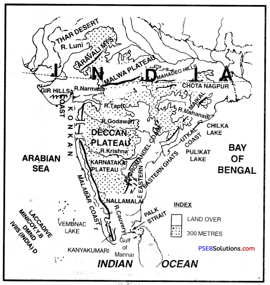
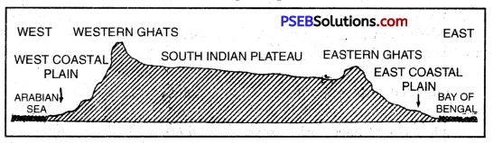
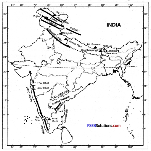
1. The Arabian Sea Branch. The Arabian Sea branch of the monsoons strikes (Sahyadris) the Western Ghats. The windward side of the Sahyadris receives very heavy rains. Crossing the Western Ghats they blow over the Deccan Plateau and Madhya Pradesh. These winds give fair amount of rainfall in these areas. Thereafter, the jr enter in the Ganga Plains and mingle with the Bay of Bengal branch. Another part of the Arabian Sea branch strikes the Saurashtra peninsula and the Kutch. It passes over West Rajasthan and along the Aravallis causing only a scanty rainfall. In Punjab and Haryana too, it joins the Bay of Bengal branch. These two branches join together and cause rains in the Western Himalayas.
2. The Bay of Bengal Branch. The Bay of Bengal branch approaches the Burmese
coast and the southeast Bangladesh. But the Arakan Hills along the Burmese coast deflect this branch to enter the Indian subcontinent. The monsoons, therefore, enter West Bengal and Bangladesh from south and southeast instead of the south-westerly direction.
this branch splits into two parts under the influence of the mightly Himalayas and the thermal low in N.W. India.
- One branch moves westward along the Ganga plains’ and reaches the Punjab plains.
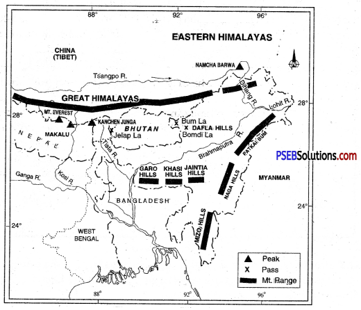
- The other branch moves up the Brahmaputra valley in the North and Northeast. It causes widespread rains in the North-eastern India. Its sub-branch strikes the Garo and Khasi Hills of the Meghalaya. Cherrapunji is situated at the head of a funnel-shaped valley in Khasi Hills. It gets the heaviest rainfall in the world due to its situation.
Distribution of Rainfall. Distribution of rainfall received from south-west monsoons is very largely governed by the relief or orography. For instance the windward side of the Western ghats gets a rainfall of over 250 centimetres. On the other hand the leeward side, receives 50 centimetres rainfall. The Northeastern States get heavy rainfall due to high Eastern Himalayas. The rainfall in the northern plains goes on decreasing from East to West. During this rainy season Kolkata receives about 120 centimetres, Patna 102 cm, Allahabad 91 cm and Delhi 56 cm.